Defense Geospatial Market Size, Share & Forecast 2026–2032
Report Highlights
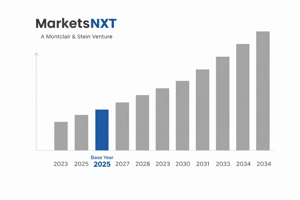
- ✓Market Size 2024: USD 14.2 Billion
- ✓Market Size 2034: USD 31.8 Billion
- ✓CAGR: 8.4%
- ✓Market Definition: The defense geospatial market encompasses geospatial intelligence (GEOINT) systems, satellite imagery, geographic information systems (GIS), and related analytics platforms used by military, intelligence, and national security agencies for situational awareness, mission planning, and threat analysis.
- ✓Leading Companies: Maxar Technologies, Esri, Leidos, BAE Systems, Palantir Technologies
- ✓Base Year: 2025
- ✓Forecast Period: 2026–2034
Analyst Recommendation — Prioritize Multi-Source Data Contracts: Procurement directors should issue multi-vendor geospatial data contracts before Q2 2026 to avoid dependency on any single imagery provider, particularly given Maxar's 2023 acquisition by Advent International introducing financial and operational uncertainty into a previously stable supply chain.
Understanding the Defense Geospatial Market: A Buyer's Overview
The defense geospatial market delivers the foundational intelligence layer on which modern military operations depend — from mission-level terrain analysis and route planning to strategic-level threat monitoring across sovereign borders. Core deliverables include satellite imagery, multispectral and hyperspectral data, 3D elevation models, moving target intelligence, and integrated GIS platforms that fuse these inputs into actionable operational pictures. Primary buyers are national defense ministries, intelligence agencies, special operations commands, and increasingly, NATO-aligned coalition forces seeking interoperable geospatial standards across multi-national mission sets. Commercial buyers in border security and maritime domain awareness are a growing secondary segment.
From a procurement perspective, the market is structured around a small number of vertically integrated prime contractors — Maxar, Leidos, BAE Systems — supplemented by specialized analytics vendors and a rapidly expanding tier of commercial small-satellite operators. Competitive tenders for large national geospatial programs are infrequent but high-value, often structured as multi-year indefinite-delivery, indefinite-quantity (IDIQ) contracts ranging from five to ten years. Pricing models combine fixed satellite access licensing, per-task imagery fees, and software-as-a-service arrangements for analytics platforms. Buyers should anticipate intense competition among two to four credible primes, with smaller contracts attracting a broader range of specialized vendors.
Factors Driving Defense Geospatial Procurement
Three specific procurement triggers are accelerating defense geospatial spending right now. First, NATO's 2022 Strategic Concept mandate requires all alliance members to achieve interoperable GEOINT standards by 2025, forcing European defense ministries — particularly Germany, Poland, and the Netherlands — to modernize legacy geospatial infrastructure on compressed timelines. Second, the proliferation of low Earth orbit commercial satellite constellations from operators like Planet Labs, Satellogic, and BlackSky has created a near-real-time imagery availability threshold that defense planners now treat as a baseline operational requirement, compelling agencies to contract for revisit rates measured in hours rather than days.
Third, the operational lessons from Ukraine have created an urgent procurement driver around integrated multi-domain geospatial analytics. The documented effectiveness of commercially-sourced satellite imagery combined with AI-assisted change detection — demonstrated in Maxar's published imagery of Russian force movements in 2022 — has driven defense appropriations committees in the U.S., U.K., and Australia to accelerate geospatial intelligence modernization budgets. The U.S. Space Force's acquisition of commercial geospatial services under the Global EO Broker contract vehicle represents a direct budgetary response, with committed spending exceeding USD 900 million over five years.
Challenges Buyers Face in the Defense Geospatial Market
Vendor lock-in is the most consequential structural challenge in this market. Buyers who standardize on a single GIS platform — most commonly Esri's ArcGIS, which holds an estimated 70% share of military GIS deployments globally — face enormous switching costs when contract renewal cycles arrive. Data schemas, analyst workflows, and interoperability standards become deeply embedded over five to ten year periods, leaving procurement offices with limited meaningful competition at renewal. Simultaneously, highly classified geospatial programs create a parallel problem: only cleared vendors can compete, dramatically narrowing the competitive field and reducing buyer leverage on pricing, performance guarantees, and innovation commitments.
Total cost of ownership surprises are a persistent second challenge. Buyers frequently underestimate the cost of data management infrastructure required to process and store high-resolution imagery at operational volumes — a single high-priority area of interest at sub-meter resolution generates terabytes of data per collection cycle. Agencies that procured imagery contracts without co-planning ground infrastructure have encountered costs two to three times initial estimates. A third challenge is skills scarcity: qualified GEOINT analysts capable of operating advanced fusion platforms are in chronic short supply, meaning organizations purchase capable systems they lack the trained personnel to exploit fully, undermining program ROI from day one.
Emerging Opportunities Worth Watching in Defense Geospatial Analytics
The most significant near-term opportunity is synthetic aperture radar (SAR) data integration into standard defense workflows. SAR's all-weather, day-night imaging capability makes it operationally critical in contested environments where optical systems are degraded. Vendors including Capella Space, ICEYE, and Umbra have reached commercial SAR resolution thresholds — sub-50-centimeter in Umbra's case — that were classified military capabilities just five years ago. Defense buyers who establish SAR data contracts now, before demand spikes post-2026, will lock in preferential pricing structures and access priority before the anticipated surge in allied-nation procurement compresses commercial capacity.
A second opportunity lies in geospatial digital twin technology, where persistent, real-time 3D environment models are fused with sensor feeds, logistics data, and intelligence overlays to support command-level decision-making. Early adopters including the U.S. Army Futures Command and the British Army's Integrated Warfighting concept programs are piloting digital terrain twin systems that reduce mission planning cycle times by over 40%. Vendors in this space — Vricon, CesiumGS, and Presagis — represent a competitive layer below the traditional primes where buyers can establish cost-effective contracts before these capabilities are absorbed into larger prime contractor portfolios through anticipated M&A activity by 2027.
How to Evaluate Defense Geospatial Suppliers
The three most important evaluation criteria specific to this market are data provenance and ground truth validation capability, platform interoperability with NATO STANAG geospatial standards, and demonstrated performance in degraded or contested network environments. Data provenance matters because buyers are increasingly fusing commercial and classified sources; suppliers must demonstrate auditable chain-of-custody documentation that satisfies intelligence community oversight requirements. STANAG interoperability is non-negotiable for any NATO-aligned buyer — a supplier that cannot deliver data in NVG, CDB, or GEOTIFF formats compliant with STANAG 7074 and 4559 creates downstream integration burdens that eliminate claimed cost advantages. Performance in degraded environments separates operationally credible suppliers from those built exclusively for permissive network conditions.
The most common evaluation mistake is over-weighting imagery resolution specifications at the expense of revisit rate, tasking responsiveness, and data latency. A supplier offering 30-centimeter resolution with a 72-hour tasking cycle is operationally inferior to one delivering 50-centimeter resolution with a four-hour response window in most tactical use cases. Buyers also frequently accept vendor-supplied benchmark demonstrations using pre-selected, favorable imagery rather than requiring live tasking of an operationally relevant area under realistic conditions. The differentiating test for any serious supplier is the ability to demonstrate end-to-end workflow — from tasking request through imagery delivery, automated exploitation, and integration into the buyer's existing command system — within a defined and contractually committed service level agreement.
Market at a Glance
| Metric | Detail |
|---|---|
| Market Size 2024 | USD 14.2 Billion |
| Market Size 2034 | USD 31.8 Billion |
| Growth Rate (CAGR) | 8.4% |
| Most Critical Decision Factor | Tasking responsiveness and NATO STANAG interoperability compliance |
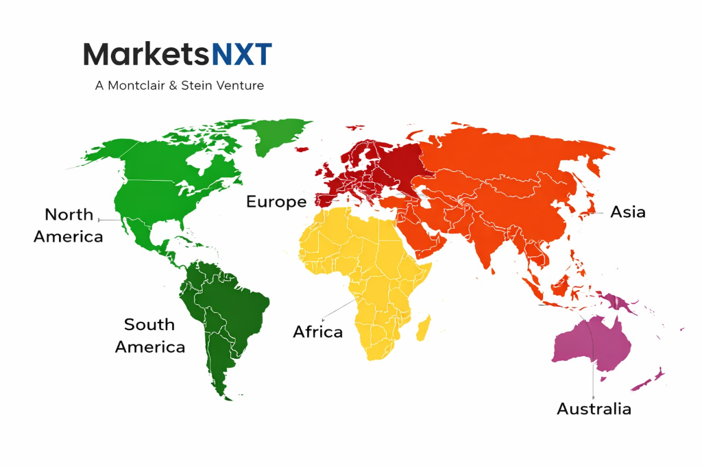
| Largest Region | North America |
| Competitive Structure | Oligopoly with emerging commercial tier disruption |
Regional Demand: Where Defense Geospatial Buyers Are
North America remains the most mature and highest-spending buyer base, anchored by the U.S. NGA, U.S. Space Force, and the broader U.S. Intelligence Community, which collectively account for over 45% of global defense geospatial spending. Canada's Department of National Defence is expanding its GEOINT capabilities under the Strong, Secure, Engaged defense policy, representing a secondary but fast-growing North American demand node. European demand is accelerating sharply — Germany's Bundeswehr Geoinformationsdienst, France's DGA, and Poland's newly expanded defense budget are all driving geospatial modernization investments, with European buyers placing particular emphasis on supplier sovereignty and data residency within EU jurisdictions.
The Asia-Pacific region is the fastest-growing demand market, driven by Indo-Pacific strategic competition and territorial dispute monitoring requirements. Australia, Japan, and South Korea are all expanding GEOINT procurement under bilateral defense frameworks with the United States. India's Defence Space Agency represents a significant emerging buyer with strong preference for domestic supplier development under the Make in India initiative, creating partnership and offset requirements that international vendors must plan for explicitly. The Middle East, led by Saudi Arabia, the UAE, and Israel, constitutes a specialized demand cluster where buyers require real-time maritime and border surveillance capability, creating a niche but high-value procurement segment with distinct technical and political constraints affecting supplier selection.
Leading Market Participants
- Maxar Technologies
- Esri
- Leidos
- BAE Systems
- Palantir Technologies
- Airbus Defence and Space
- L3Harris Technologies
- Planet Labs
- Hexagon AB
- Capella Space
What Comes Next for Defense Geospatial
The most consequential structural change over the next three to five years is the convergence of geospatial intelligence with signals intelligence (SIGINT) and cyber intelligence into unified multi-domain intelligence platforms. The U.S. NGA's GEOINT Pathfinder program and the UK's Project Minerva both explicitly target this fusion architecture, which will fundamentally alter the supplier qualification landscape — vendors that cannot demonstrate multi-INT integration capability will be progressively excluded from prime contract competition. Simultaneously, quantum sensing technology is advancing toward field-deployable navigation and subsurface imaging systems, with DARPA's Quantum Sensing program projecting prototype delivery by 2027, which will create an entirely new geospatial data category requiring new exploitation frameworks.
The practical implication for buyers is that current geospatial platform investments must be architected for data extensibility, not just current-state imagery workflows. Buyers should issue open architecture requirements in all geospatial procurement actions initiated after Q3 2025, mandating API-accessible data layers and modular analytics frameworks that can ingest new sensor types without requiring platform replacement. Locking into closed-architecture systems today creates a near-certain modernization cost liability by 2028. Procurement teams should also begin workforce planning for multi-INT analyst profiles now, as the talent pipeline for personnel who can operate at the intersection of GEOINT, SIGINT, and AI-assisted exploitation is currently insufficient to meet projected program demands across NATO-aligned defense establishments.
Market Segmentation
By Solution Type
- Geospatial Imagery and Data
- Geographic Information Systems (GIS)
- GEOINT Analytics Platforms
- 3D Mapping and Digital Terrain Models
- Moving Target Indicator Systems
- Geospatial-as-a-Service
By Platform
- Satellite-Based
- Airborne and UAV-Based
- Ground-Based
- Maritime-Based
- Space-Based SAR
By Application
- Mission Planning and Navigation
- Surveillance and Reconnaissance
- Border and Maritime Security
- Disaster Response and Crisis Management
- Infrastructure and Asset Monitoring
- Target Acquisition and Strike Support
By End User
- Army
- Navy
- Air Force and Space Command
- Intelligence Agencies
- Homeland Security and Border Agencies
- Allied and Coalition Forces
Frequently Asked Questions
The U.S. government primarily uses IDIQ contract vehicles such as the NGA's EnhancedView and Global EO Broker programs, which allow multiple task orders against a ceiling value over multi-year periods. These vehicles enable faster procurement cycles than full-and-open competition while maintaining compliance with FAR requirements.
Buyers must establish clear data handling annexes in contracts that specify classification levels, foreign national access restrictions, and approved storage environments before contract award. Failure to define these requirements upfront results in operationally unusable data that cannot be integrated into classified mission systems.
A realistic deployment timeline for a brigade-level GEOINT platform, including infrastructure readiness, security accreditation, and analyst training, is 18 to 24 months from contract award. Compressed timelines below 12 months consistently produce incomplete analyst proficiency and reduced operational effectiveness.
Buyers should require vendors to demonstrate disconnected, intermittent, and low-bandwidth operations during source selection, using a defined test scenario rather than accepting vendor-supplied documentation. Contracts must include specific performance standards for degraded-environment operations, with liquidated damages provisions tied to measured uptime metrics.
Most defense ministries outside the United States require technology transfer, local content minimums of 20 to 40 percent, or co-development agreements when awarding geospatial contracts to foreign vendors. Buyers should budget an additional 6 to 12 months for offset negotiation and compliance framework establishment before contract execution.
Frequently Asked Questions
Market Segmentation
- Geospatial Imagery and Data
- Geographic Information Systems (GIS)
- GEOINT Analytics Platforms
- 3D Mapping and Digital Terrain Models
- Moving Target Indicator Systems
- Geospatial-as-a-Service
- Satellite-Based
- Airborne and UAV-Based
- Ground-Based
- Maritime-Based
- Space-Based SAR
- Mission Planning and Navigation
- Surveillance and Reconnaissance
- Border and Maritime Security
- Disaster Response and Crisis Management
- Infrastructure and Asset Monitoring
- Target Acquisition and Strike Support
- Army
- Navy
- Air Force and Space Command
- Intelligence Agencies
- Homeland Security and Border Agencies
- Allied and Coalition Forces
Table of Contents
Research Framework and Methodological Approach
Information
Procurement
Information
Analysis
Market Formulation
& Validation
Overview of Our Research Process
MarketsNXT follows a structured, multi-stage research framework designed to ensure accuracy, reliability, and strategic relevance of every published study. Our methodology integrates globally accepted research standards with industry best practices in data collection, modeling, verification, and insight generation.
1. Data Acquisition Strategy
Robust data collection is the foundation of our analytical process. MarketsNXT employs a layered sourcing model.
- Company annual reports & SEC filings
- Industry association publications
- Technical journals & white papers
- Government databases (World Bank, OECD)
- Paid commercial databases
- KOL Interviews (CEOs, Marketing Heads)
- Surveys with industry participants
- Distributor & supplier discussions
- End-user feedback loops
- Questionnaires for gap analysis
Analytical Modeling and Insight Development
After collection, datasets are processed and interpreted using multiple analytical techniques to identify baseline market values, demand patterns, growth drivers, constraints, and opportunity clusters.
2. Market Estimation Techniques
MarketsNXT applies multiple estimation pathways to strengthen forecast accuracy.
Bottom-up Approach
Aggregating granular demand data from country level to derive global figures.
Top-down Approach
Breaking down the parent industry market to identify the target serviceable market.
Supply Chain Anchored Forecasting
MarketsNXT integrates value chain intelligence into its forecasting structure to ensure commercial realism and operational alignment.
Supply-Side Evaluation
Revenue and capacity estimates are developed through company financial reviews, product portfolio mapping, benchmarking of competitive positioning, and commercialization tracking.
3. Market Engineering & Validation
Market engineering involves the triangulation of data from multiple sources to minimize errors.
Extensive gathering of raw data.
Statistical regression & trend analysis.
Cross-verification with experts.
Publication of market study.
Client-Centric Research Delivery
MarketsNXT positions research delivery as a collaborative engagement rather than a static information transfer. Analysts work with clients to clarify objectives, interpret findings, and connect insights to strategic decisions.