Drone GIS Mapping Market Size, Share & Forecast 2026–2034
Report Highlights
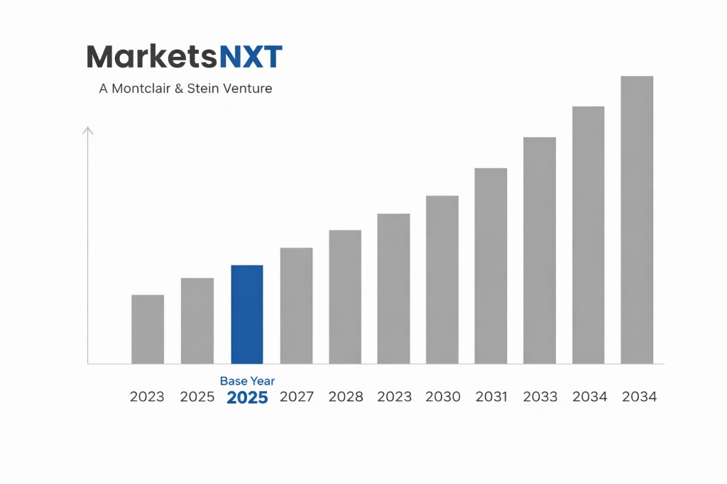
- ✓Market Size 2024: USD 632.4 million
- ✓Market Size 2034: USD 3,187.6 million
- ✓CAGR: 17.6%
- ✓Market Definition: Drone GIS mapping encompasses the use of unmanned aerial vehicles equipped with sensors, cameras, and positioning systems to collect geospatial data for geographic information system analysis. End applications span land surveying, infrastructure inspection, agriculture, mining, and urban planning.
- ✓Leading Companies: Trimble Inc., Esri, DJI Enterprise, Pix4D, Hexagon AB
- ✓Base Year: 2025
- ✓Forecast Period: 2026–2034
Analyst Recommendation — Lock Data Portability Now: Buyers committing to drone GIS mapping programmes in 2025 must negotiate open-format data export clauses and platform-agnostic deliverable standards before signing any software agreement. Failure to do so transfers significant leverage to vendors at renewal, inflating three-year costs by an estimated 20–30%.
Understanding Drone GIS Mapping: A Buyer's Overview
Drone GIS mapping delivers high-resolution geospatial datasets — orthomosaics, digital elevation models, point clouds, and multispectral indices — that replace or augment traditional ground survey and manned aerial methods. Primary buyers include government land management agencies, construction and engineering firms, mining operators, precision agriculture businesses, utilities managing linear infrastructure, and urban planning departments. These buyers are purchasing not just flight hardware but an integrated capability: sensor payloads, real-time kinematic positioning, photogrammetry or LiDAR processing software, and cloud-based data delivery. The value proposition is faster data acquisition, lower cost per hectare surveyed, and repeatability at intervals that legacy methods cannot match economically.
From a procurement perspective, the market divides into hardware vendors, software platform providers, and managed service operators — each with distinct commercial models. Hardware procurement is typically a capital purchase with a three-to-five-year replacement cycle, while software is subscription-based on annual or multi-year terms. Managed service contracts bundle both under per-project or annual retainer pricing, which is increasingly preferred by public sector buyers who lack in-house drone pilots. The supplier landscape includes roughly a dozen credible full-capability vendors globally, but the market is dominated by three to four platforms. Tender processes are competitive but technically complex, and specifications that do not clearly define data accuracy standards frequently attract non-compliant bids that inflate evaluation costs.
Factors Driving Drone GIS Mapping Procurement
Three operational triggers are accelerating spending right now. First, national infrastructure investment programmes — including the US Infrastructure Investment and Jobs Act, the EU's TEN-T network upgrades, and Australia's infrastructure pipeline — require geospatial baselines and progress monitoring at a scale and frequency that traditional survey methods cannot support within project timelines. Engineering firms on these contracts are procuring drone GIS mapping capabilities urgently to meet deliverable schedules, not as a long-term strategic investment but as an immediate operational necessity. Second, mining regulatory requirements in jurisdictions including Canada, Chile, and South Africa now mandate quarterly volumetric surveys of tailings storage facilities for safety compliance, creating a recurring procurement need that cannot be deferred without regulatory consequence.
Third, precision agriculture adoption — driven by subsidy programmes in the EU's Common Agricultural Policy reform and USDA conservation programmes — is compelling agribusiness operators to deploy multispectral drone mapping for crop health monitoring, irrigation planning, and yield documentation. These buyers are entering the market for the first time and are often procuring turnkey managed services rather than building internal capability. The combination of regulatory mandates, infrastructure investment cycles, and agricultural digitalisation represents a confluence of demand drivers that is compressing procurement decision timelines significantly across all three segments and rewarding suppliers who can demonstrate rapid deployment readiness and certified data accuracy.
Challenges Buyers Face in Drone GIS Mapping
The most operationally consequential challenge is airspace regulatory complexity. BVLOS (beyond visual line of sight) operations — which dramatically improve survey productivity over large areas — remain restricted under FAA Part 107, EASA regulations, and equivalent frameworks in most jurisdictions. Buyers who procure systems on the assumption that BVLOS approvals will follow often face 12-to-18-month operational gaps between hardware delivery and full capability deployment. This is particularly acute for utilities and pipeline operators whose asset corridors stretch hundreds of kilometres and where BVLOS is not optional but essential to the business case. Regulatory approval timelines are not a risk that suppliers can mitigate; buyers must build them into programme plans explicitly before committing capital.
A second major challenge is total cost of ownership miscalculation. Buyers routinely underestimate the cost of data processing infrastructure, software licensing escalations, pilot certification and recurrency training, maintenance, and insurance. A drone GIS mapping programme that appears to cost USD 180,000 at hardware procurement frequently runs to USD 400,000 or more over three years when all operational costs are included. Vendor lock-in compounds this: once a project database is built on a proprietary platform such as DroneDeploy or Trimble Connect, migration to a competing system requires re-processing historical datasets, which is both expensive and technically risky. Buyers who do not negotiate data portability terms at contract initiation consistently report the highest total cost overruns in the market.

Emerging Opportunities Worth Watching in Drone GIS Mapping
The most significant near-term opportunity is the convergence of drone GIS mapping with digital twin infrastructure. Construction and asset management buyers are beginning to specify drone mapping deliverables not as standalone surveys but as dynamic inputs to BIM and GIS-integrated digital twin platforms. This shifts the commercial relationship from a project-by-project transaction to a continuous data service contract, fundamentally improving supplier revenue predictability and giving buyers persistent situational awareness of asset condition. Vendors including Bentley Systems and Autodesk are actively building drone data ingestion workflows into their digital twin products, and buyers who align procurement now with these platforms will gain compounding analytical value over subsequent years.
A second opportunity is the emergence of AI-powered automated change detection, which is reducing the manual interpretation burden that has historically constrained how frequently organisations update their geospatial datasets. Startups including Nearmap and SkyFi are deploying machine learning models that flag infrastructure changes, vegetation encroachment, or erosion events automatically from repeat survey comparisons, delivering actionable alerts rather than raw data files. For utility and transportation asset owners, this transforms drone GIS mapping from a periodic survey tool into a continuous monitoring system. Buyers in these sectors should evaluate AI analytics capability as a primary selection criterion in upcoming tenders, rather than treating it as a value-add feature to negotiate post-award.
How to Evaluate Drone GIS Mapping Suppliers
Three criteria are genuinely differentiating in this market and should carry the greatest weight in supplier evaluation. First, demonstrated data accuracy under real-world conditions: require suppliers to provide independent third-party validation reports showing ground control point accuracy across terrain types representative of your operating environment. Claimed centimetre-level accuracy under ideal conditions is not a reliable proxy for performance in dense canopy, steep terrain, or high-wind coastal environments. Second, regulatory compliance track record: evaluate the supplier's history of obtaining BVLOS waivers, temporary flight restriction approvals, and foreign object debris compliance certifications in jurisdictions that match your operational footprint. A supplier with strong domestic approvals but no international regulatory experience is a material risk for global programmes. Third, processing platform interoperability: assess whether the supplier's output formats are compatible with your existing GIS infrastructure — specifically ESRI ArcGIS, QGIS, or Bentley ecosystems — without requiring proprietary middleware.
The most common evaluation mistake buyers make is over-weighting hardware specifications — camera resolution, flight endurance, wind resistance ratings — at the expense of the data processing and delivery workflow. A drone that captures excellent imagery but routes it through a slow, proprietary processing pipeline that delivers outputs in non-standard formats destroys operational value regardless of sensor quality. The second common error is failing to conduct reference checks with buyers who have run programmes at comparable scale and complexity. Suppliers who look excellent in demo environments frequently underperform on large-area surveys requiring coordinated multi-aircraft operations, real-time data validation, and integration with enterprise asset management systems. Request at minimum three customer references who have completed programmes of equivalent scope before shortlisting.
Market at a Glance
| Metric | Detail |
|---|---|
| Market Size 2024 | USD 632.4 million |
| Market Size 2034 | USD 3,187.6 million |
| Growth Rate (CAGR) | 17.6% |
| Most Critical Decision Factor | Data accuracy validation and software platform interoperability |
| Largest Region | North America |
| Competitive Structure | Moderately consolidated with dominant platform vendors and fragmented service operators |
Regional Demand: Where Drone GIS Mapping Buyers Are
North America is the most mature buyer base, driven by established FAA Part 107 certification infrastructure, deep enterprise GIS adoption anchored on ESRI's dominant market position, and large-scale infrastructure and energy sector demand. US buyers exhibit the highest average contract values globally, particularly in utility corridor inspection and federal land management. Canada's mining sector represents a rapidly growing sub-segment, with demand concentrated in British Columbia, Ontario, and the Northwest Territories. Europe's buyer base is sophisticated but more fragmented due to the patchwork of national airspace regulations beneath the EASA framework, which complicates cross-border programme management for multinational buyers operating across the EU and UK simultaneously.
Asia Pacific is the fastest-growing demand region, led by China — where DJI's domestic dominance gives local buyers a distinct hardware cost advantage — and by Australia, where mining and agricultural applications are scaling rapidly under supportive CASA regulatory frameworks. India is emerging as a significant buyer following the government's drone liberalisation policy of 2021, with geospatial mapping programmes now embedded in the national PM GatiShakti infrastructure planning initiative. The Middle East is a high-value but concentrated market, with large-scale urban planning and oil-and-gas asset inspection programmes in the UAE and Saudi Arabia driving demand for premium managed service contracts. Latin America, led by Brazil's agribusiness and mining sectors, is an underserved market where supplier availability lags demand, creating procurement lead time risks for buyers who have not pre-qualified regional service providers.
Leading Market Participants
- Trimble Inc.
- Esri
- DJI Enterprise
- Pix4D
- Hexagon AB
- DroneDeploy
- Bentley Systems
- senseFly (AgEagle Aerial Systems)
- Parrot Drones
- Nearmap
What Comes Next for Drone GIS Mapping
The most consequential structural change over the next three to five years is the mandatory integration of remote identification and UTM (unmanned traffic management) systems, which will fundamentally alter how drone GIS mapping operations are planned, approved, and executed. The FAA's Remote ID rule, EASA's U-Space framework, and equivalent national implementations will require all commercial operators to register flight paths and broadcast real-time identification data, adding administrative overhead but simultaneously unlocking BVLOS approvals at scale. Buyers should expect that by 2027, BVLOS-capable managed service providers will command a significant pricing premium over VLOS-only operators, and procurement specifications written today should explicitly require UTM compatibility to avoid contract renegotiation costs at that inflection point.
Supplier consolidation is accelerating and will reshape the competitive landscape materially by 2028. Mid-tier hardware manufacturers lacking proprietary software ecosystems are already losing ground to integrated platform vendors, and several managed service operators are likely to be acquired by GIS software majors seeking to vertically integrate data collection capabilities. For buyers, this consolidation risk means that a supplier who wins a five-year contract today as an independent entity may be operating under different commercial terms, support structures, or platform roadmaps by year three. Buyers should build contract clauses that protect data sovereignty, guarantee continued software interoperability, and include exit provisions in the event of a change of control — particularly for programmes where continuity of historical dataset integrity is operationally critical.
Market Segmentation
By Platform Type
- Fixed-Wing Drones
- Multi-Rotor Drones
- Hybrid VTOL Drones
- Single-Rotor Drones
By Sensor Type
- RGB Cameras
- LiDAR Sensors
- Multispectral Sensors
- Hyperspectral Sensors
- Thermal Infrared Sensors
By Application
- Land Surveying and Cadastral Mapping
- Infrastructure Inspection and Monitoring
- Precision Agriculture
- Mining and Quarry Volumetrics
- Urban Planning and Smart Cities
- Environmental and Forestry Management
By End-User Industry
- Government and Public Sector
- Construction and Engineering
- Agriculture
- Mining and Oil and Gas
- Utilities and Telecommunications
- Defence and Security
Frequently Asked Questions
Buyers should specify horizontal and vertical accuracy at the 95% confidence level with a defined ground control point density relative to survey area. For infrastructure and cadastral applications, a ground sample distance of 2–3 cm and vertical accuracy of 5 cm RMSE is the accepted industry benchmark under controlled conditions.
Contracts must mandate deliverables in open formats — LAS or LAZ for point clouds, GeoTIFF for orthomosaics, and OGC-compliant vector outputs — and prohibit proprietary format-only deliverables. Include a data portability clause requiring the vendor to provide full project archives in open formats within 30 days of contract termination.
For a mid-scale operation covering 500–2,000 hectares per month, total three-year costs typically range from USD 350,000 to USD 600,000, inclusive of hardware, software licensing, pilot certification, maintenance, insurance, and data storage. Buyers who budget only for hardware acquisition consistently underestimate programme costs by 40–60%.
BVLOS waiver approval under FAA and EASA frameworks currently takes 6–18 months from application to operational approval, depending on airspace complexity and the operator's compliance history. Buyers must factor regulatory lead times into programme launch dates and avoid committing project delivery schedules that depend on BVLOS approval before it is granted.
Managed services are preferable when annual survey requirements fall below 500 flight hours, when internal GIS staff lack photogrammetry processing expertise, or when the operating environment requires frequent regulatory approvals in multiple jurisdictions. In-house capability delivers better economics above 800 annual flight hours when a stable team and consistent asset base can be maintained.
Frequently Asked Questions
Market Segmentation
- Fixed-Wing Drones
- Multi-Rotor Drones
- Hybrid VTOL Drones
- Single-Rotor Drones
- RGB Cameras
- LiDAR Sensors
- Multispectral Sensors
- Hyperspectral Sensors
- Thermal Infrared Sensors
- Land Surveying and Cadastral Mapping
- Infrastructure Inspection and Monitoring
- Precision Agriculture
- Mining and Quarry Volumetrics
- Urban Planning and Smart Cities
- Environmental and Forestry Management
- Government and Public Sector
- Construction and Engineering
- Agriculture
- Mining and Oil and Gas
- Utilities and Telecommunications
- Defence and Security
Table of Contents
Research Framework and Methodological Approach
Information
Procurement
Information
Analysis
Market Formulation
& Validation
Overview of Our Research Process
MarketsNXT follows a structured, multi-stage research framework designed to ensure accuracy, reliability, and strategic relevance of every published study. Our methodology integrates globally accepted research standards with industry best practices in data collection, modeling, verification, and insight generation.
1. Data Acquisition Strategy
Robust data collection is the foundation of our analytical process. MarketsNXT employs a layered sourcing model.
- Company annual reports & SEC filings
- Industry association publications
- Technical journals & white papers
- Government databases (World Bank, OECD)
- Paid commercial databases
- KOL Interviews (CEOs, Marketing Heads)
- Surveys with industry participants
- Distributor & supplier discussions
- End-user feedback loops
- Questionnaires for gap analysis
Analytical Modeling and Insight Development
After collection, datasets are processed and interpreted using multiple analytical techniques to identify baseline market values, demand patterns, growth drivers, constraints, and opportunity clusters.
2. Market Estimation Techniques
MarketsNXT applies multiple estimation pathways to strengthen forecast accuracy.
Bottom-up Approach
Aggregating granular demand data from country level to derive global figures.
Top-down Approach
Breaking down the parent industry market to identify the target serviceable market.
Supply Chain Anchored Forecasting
MarketsNXT integrates value chain intelligence into its forecasting structure to ensure commercial realism and operational alignment.
Supply-Side Evaluation
Revenue and capacity estimates are developed through company financial reviews, product portfolio mapping, benchmarking of competitive positioning, and commercialization tracking.
3. Market Engineering & Validation
Market engineering involves the triangulation of data from multiple sources to minimize errors.
Extensive gathering of raw data.
Statistical regression & trend analysis.
Cross-verification with experts.
Publication of market study.
Client-Centric Research Delivery
MarketsNXT positions research delivery as a collaborative engagement rather than a static information transfer. Analysts work with clients to clarify objectives, interpret findings, and connect insights to strategic decisions.